The Rail Baltica railway in Latvia, spanning 265 kilometers, will traverse more than 200 bridges throughout the country. However, one specific bridge stands out amongst the rest – the combined road-rail or dual bridge over the Daugava near Salaspils. Due to its scale, technical and operational features, the bridge has been labeled a world-class engineering construction even before its completion.
This significant landmark structure, of which there are only 3 similar bridges in Europe (high-speed rail combined with highway) will be one of the most complex structures in the Baltics and on the Rail Baltica high-speed line.
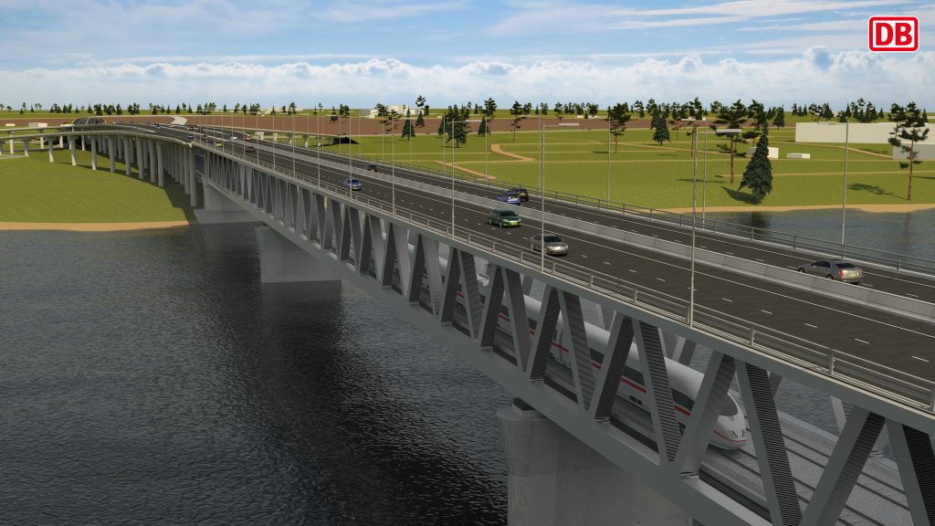
Significant object in the national road strategy
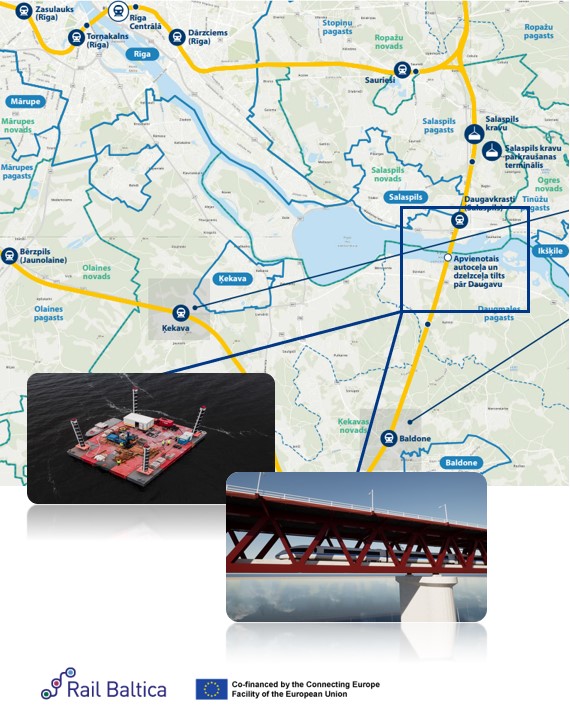
The bridge over the Daugava will connect two counties: it will functionally connect the Riga bypass road A4 on the right bank of the river (Salaspils county) with the P85 highway on the left bank (Ķekava county). For this purpose, it is planned to design and build multi-level circular road junctions on both banks. The bridge is already acknowledged by experts as an important contribution to Latvia’s transport system. Its construction will aid in the reconstruction of the Riga bypass road and is listed as a priority in the Latvian national highway strategy until 2040. The plan aims to establish a safe and efficient national highway network, enabling Riga bypass accessibility from any administrative center in Latvia within two hours or less. The dual bridge’s completion will fulfill European Union regulations regarding high-speed road construction in the primary network of the Trans-European Transport Network (TEN-T). Additionally, it will lessen the load on the Riga HPP dam from various transport vehicles. The combined bridge will connect to the Ķekava bypass, creating a seamless route for the Riga bypass.
A rational decision
The construction of a two-level bridge over the Daugava was not a project whim, but a well-considered decision. Before the government could support the design of the combined road and railway bridge over the Daugava, considerable homework had been done, conducting thorough research, and considering many aspects of the bridge. In 2009, Latvian State Roads studied ways to develop the Riga bypass, considering several development scenarios, while in 2016, Rail Baltica’s feasibility study was carried out. The position of the railway was fixed to pass over the Daugava overflow, and in 2018, the railway track was analyzed by experts to optimize technical solutions. Last year, a company association consisting of Egis Rail S.A., DB Engineering & Consulting GmbH, and SIA Olimps was chosen to design the Rail Baltica main track and the Vangaži–Salaspils–Misa section, which includes the dual bridge.
The initial design stage involved value engineering, where designers were directed to compare the costs, solutions, and parameters of various structures. Several bridge options were analyzed to identify the best solution for this crossing point, while also assessing the surrounding infrastructure such as the road network connection. Designers explored the feasibility of building two separate bridges for road and railway traffic or a combined bridge accommodating both. They evaluated the location of the bridge infrastructure, weighed the respective advantages and disadvantages, and analyzed different constructive solutions.
Dual bridge: more economically viable
Preparation for the construction project involved comparing the viability of two separate bridges versus a dual bridge. The study confirmed that the dual-level bridge was economically feasible. After the Rail Baltica environmental impact assessment was completed, a thorough analysis was conducted to compare the construction and maintenance of two structures versus one. The results showed that a combined bridge was the most justifiable solution, as it would reduce loss of undeveloped land and prevent formation of a limited intermediate zone. Additionally, a combined bridge would adhere to the “build-once” principle, reduce the impact on the Daugava water body, and have a shorter construction time.
An analysis was conducted to minimize the impact on the surrounding infrastructure. It was determined that a combined bridge solution would be optimal as it would require less land and have less impact on the landscape. Additionally, the higher bridge would meet technical regulations (>9.5 m) corresponding to shipping parameters and minimize noise pollution in the residential area as two structures cause more pollution. While a dual bridge may be cheaper to construct, the costs of highway node connections, land expropriation compensations, anti-noise measures, and communication reconstruction would make the combined bridge more cost-effective. The joint bridge plan would also streamline maintenance and funding. The designated construction site for the combined bridge is the most suitable as it has already been evaluated and reserved for road junctions in territorial plans of the municipalities.
Based on the alternatives prepared by DB Engineering & Consulting in partnership with Egis and Olimps during the value engineering phase, in late 2020 the Ministry of Transport in Latvia chose the alternative with the design of the combined road-rail bridge as well as the major A4/A6 highway junction to the north of the river and the A4/P85 junction to the south of the river.
Major research works
After completing the conceptual design and defining the general arrangement of the bridge, the design team initiated geological investigations in the riverbed during the summer of 2021 to gather additional input data. For this, a 25m x 25m large platform was constructed to be able to access the 8 pier locations in the river. The platform enabled the drilling team to keep the drilling rig securely and accurately in the correct position. To fix the platform and keep it stable even in strong winds, the four piers at each corner of the platform were projected down to the bottom of the river.
As the area of the Daugava River in which investigations are being carried out is subject to the risk of unexploded ordnances from World War 1 and 2, prior to the launch of investigations, a team of specialized divers from Naval Forces of the Latvian National Armed Forces conducted a visual and sonar inspection of the riverbed to ensure that the investigation areas were free from such objects.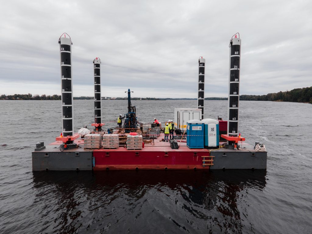
In total 8 locations were investigated. For this, the team drilled up to a depth of 35-50 m under the riverbed (depending on the soil conditions), took various samples, and performed several laboratory tests on these. The Daugava River itself is up to 22 m deep.
To ensure the best results in the investigations, DB Engineering & Consulting is combining the local know-how in drilling with German supervision and experience. At the end of 2021, the Daugava River investigations were successfully completed, and soil samples are currently being tested in the laboratories. The results of the investigations and laboratory tests will give the team valuable information for the design and allow them to develop the most suitable solution.
Considering the specific geological circumstances in certain areas of the design section, additional geophysical investigation works were necessary to limit the risk of undetected karst voids which could later lead to sinkholes along the railway line, presenting a major safety concern for an operating railway line. During the geophysical investigations, diodes were put in the upper layer of the soil, which measure the electrical resistivity of the underlying layers at a depth of up to 30m.
As a result of such investigations, a 2D longitudinal cross-section of the underlying layers can be generated, giving information about the electrical resistivity of certain areas of the soil. In combination with the results of drillings, those results can be used to further pinpoint locations for additional investigations which will minimize the risk of undetected karst voids.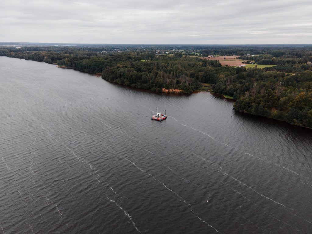
Within the project scope, on this Rail Baltica mainline section geological investigations with a total length of approximately 14 800 m will be drilled. All investigation results will enable the design team to develop and fine-tune their design solutions and ensure the most economic and technically suitable design for future construction works. To ensure the coordination between all involved design disciplines and stakeholders, the design is being developed in BIM design.
Basic parameters of the 1.1 km long high-speed bridge
Three variations of the dual bridge design were evaluated to determine the most efficient way to connect two transportation routes while considering the technical parameters of the road and railway. The first type of bridge was evaluated with the railway on the upper platform. The second type had the railway positioned in the middle of the bridge with roads on both sides. The optimal solution was determined to be a bridge with the railway line located at the lower level, approximately 12 meters above the water, and the highway on top at a height of 22 meters above the river. This design includes 8 spans, each measuring 150 meters long. The technical design of the bridge provides that the bridge is 1.1 km long, including the height required for navigation requested by the municipalities, from the 6th to the 8th span. As such, the bridge will have a height above the water level, ranging from 8.35 to 11.80 meters, ensuring adequate shipping dimensions.
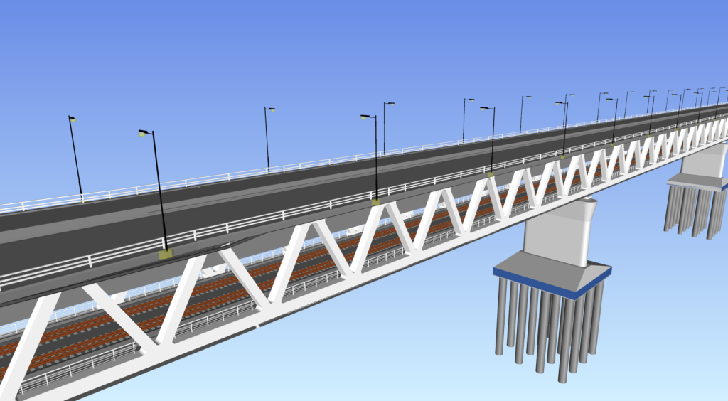
In line with the Latvian Road Development Strategy 2040, the section of the Riga Ring Road (A4) that will cross the Daugava River is planned as a high-speed road with pedestrian and cyclist access prohibited for safety reasons. To ensure the safety of less protected road users, infrastructure must be built separately and include parallel roads or a separate bridge. Considering that trains are anticipated to travel at speeds of up to 249 km/h, with the possibility of future acceleration to 300 km/h, it is not possible to include publicly accessible pedestrian and bicycle infrastructure on the bridge. In response, State Roads is conducting research into locating micromobility infrastructure between Ķegums and Riga. Solutions have been proposed to build cycle paths in sections Saulkalne-Salaspils and Daugmale-Ķekava. In future, a possibility for a micromobility crossing alternative could be considered by using the Riga HPP dam road.
A unique structure on a global scale and a strategic object of military mobility
Bridge length: 1150 m
 Bridge height above water level: 8.35–11.80 m
Span scheme: eight supports 125 m + 6×150 m + 125 m
Width:
- road section – 23.10 m (optimized NP26)
- railway section – 12.1 m
Designed speed:
- highway – 90 km/h;
- high-speed railway – 249 km/h, 200 km/h, 120 km/h
Construction:
- steel truss grid
- monolithic reinforced concrete road and railway deck
2+2 lanes for car traffic
1+1 rails for high-speed railway
The bridge is designed according to Eurocode railway and road loads
*Article based on the publication in the magazine “Būvinženieris” (issued in December 2022).
